The Canoe Is the People
Indigenous Navigation in the Pacific


Finding Land
On a clear day, low islands can be seen from about 15 km away and high islands from even further away. Signs of land can normally be seen or felt from 30 km away or more. The signs include sea life, interrupted swells GLOSSARY interrupted - broken , clouds, and te lapa (deep phosphorescence).
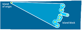
A wayfinder uses these signs to increase the size of the destination island. It is easier to head for an area of about 60 km in diameter GLOSSARY diameter - distance from one side of ta circle to the other instead of just the small island. The wayfinder can then read the signs to find land. The enlarged islands join together to form island blocks, which can be hundreds of kilometres wide.
For each island, the signs differ, and the navigator reads them differently. At night, if wayfinders do not know the area well, they may drop the sail and wait till morning before heading for land. When landing they may often have to sail into the wind and the current GLOSSARY current - the directional flow of the sea .
After a long voyage or fishing trip, there is usually a big welcome to celebrate a vaka’s safe return as well as the supplies and food that it may bring.
The great aspect about ancient navigation
Cook Islands canoe builder and wayfinder Sir Tom Davis (Papa Tom)
“The great aspect of this ancient navigation is that the Polynesians were able to find very small atolls, isolated in the middle of the sea, with nothing around except perhaps the birds to help you, and of course always, during the hot day, in the day time and in the morning especially, there is the cloud that always sits, the thermal cloud that sits over every island in the Pacific and the world.”
